Abstr:Flow and Sediment Transport in a Laboratory Model of a stretch of the Elbe River
Application Area 4: Civil Construction & HVAC
Application Challenge AC4-02
Abstract
The application challenge concerns the flow, sediment transport and bed deformation in a stretch of the river Elbe between km 506 and 513. This was investigated by the BAW (BundesAnstalt für Wasserbau - Federal Waterways Engineering and Research Institute) in field and laboratory measurements and by various 2D and 3D numerical calculations. The actual application challenge proposed here concerns only one situation for which measurements were carried out in a laboratory model and the simulation of this case with a 3D numerical model. The measurements were carried out in a scaled laboratory model of the above mentioned stretch of the river Elbe at fairly low discharge and were started from a flat movable bed. After the flow was switched on, the flow and bed were allowed to develop to an equilibrium state. The application challenge is to calculate the flow (velocity distribution and surface elevation) developing as well as the transport of sediment and the associated deformation of the bed. The input data for such a calculation are
- bed topography at an initial state,
- roughness of the bed in the area considered,
- boundary conditions for the flow: at the downstream boundary water level and at the upstream boundary either discharge or flow velocity (here constant with time)
- properties of the sediment
- boundary condition for the sediment transport: transport rate at the upstream boundary.
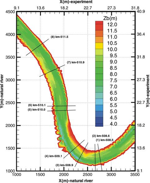
The river geometry and bed topography are given in Fig. 1 showing the distribution of bed elevation for the real river. The river is strongly curved and it also has many groynes which are only little submerged at the low water discharge investigated. The bed form was measured by stereo photogrammetry and the surface velocity by particle tracking velocimetry. The experimental situation was simulated with a 3D numerical model [1] based on the model described in [2]. 2D depth-average calculations [3, 4] of a 26 day period involving a flood in the real river have been performed earlier, but there are no direct comparisons possible with the field measurements for this period.
The stretch of the river Elbe considered includes the former border between East and West Germany. As a victim of the German post-war history, this stretch is in poorly corrected conditions so that the Federal Waterways Institute had the task to improve the conditions, in particular the navigation conditions without aggravating the flood protection and also ensuring that the ecological system of the river is not damaged. Hence this is an important case of River Hydraulics and therefore a number of experimental and numerical studies were carried out for this stretch. The test case is a real challenge due to the very complex geometry, which changes with time as the bed deforms due to deposition and erosion of bed material. Hydraulic Engineers would like to be able to predict the impact of human measures like correction constructions on the river system.
The competency of CFD calculations is to be judged mainly by how well they can simulate the velocity distribution and the bed deformation which develops with time. Important are also the water-level distribution and the cross-section averaged sediment-transport rates.
Contributors: Wolfgang Rodi - Universität Karlsruhe

